 EN
EN  it
it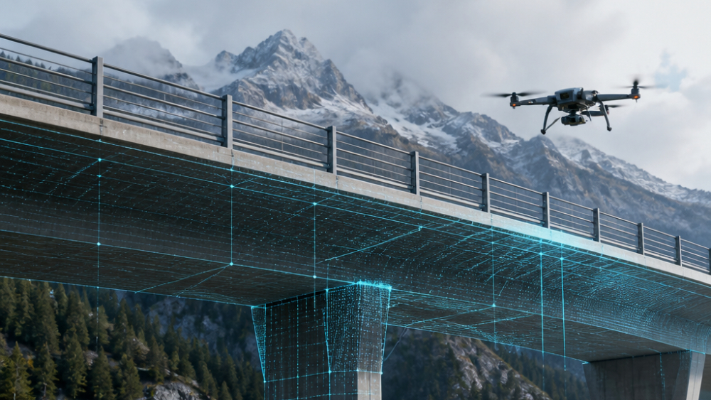
In Courmayeur, at over 2,000 metres above sea level, Autostrade dello Stato and SITMB – Società Italiana per Azioni per il Traforo del Monte Bianco – tested new technologies for land monitoring and risk prevention in the protection areas of the Mont Blanc Tunnel, turning it into an operational laboratory for the future of infrastructure monitoring.
At the Pavillon station of the Skyway cable cars, at an altitude of 2,173 metres, Autostrade dello Stato, in collaboration with SITMB, carried out a demonstration focused on the use of drones, artificial intelligence and digital platforms for infrastructure safety.
The activity focused on the protection areas of the Mont Blanc Tunnel, surveying rock faces and rockfall protection nets along the slopes. The drones acquired high-resolution images, which were then processed through artificial intelligence algorithms capable of supporting land analysis and detecting any changes in the conditions of the monitored areas.
Aerial data and AI for faster, more accurate inspections
The trial showed the potential of integrating aerial surveys, digital analysis and intelligent decision-support systems. In complex and hard-to-access environments, such as mountain areas, drones make it possible to collect detailed information while reducing time, risks and operational limits compared with traditional inspections.
The images and data acquired can be transformed into useful information for planning interventions, monitoring the evolution of the territory and strengthening prevention activities. Artificial intelligence makes it possible to analyse large amounts of data and highlight anomalies or changes that may require more in-depth checks by operators.
From mountain areas to strategic infrastructure
The initiative is part of the innovation path launched by Autostrade dello Stato, in collaboration with Polo Strategico Nazionale, through STRIVE, the platform dedicated to the development and testing of innovative projects for motorway infrastructure management.
The objective is to make the network safer, more resilient and more intelligent through the integration of sensors, drones, digital survey systems and real-time data analysis.
The model tested on Mont Blanc can also be applied to the monitoring of bridges, viaducts, tunnels and other strategic works, where continuous monitoring and the availability of up-to-date data are essential for maintenance, risk prevention and emergency management.
The role of drones in the infrastructure of the future
The field test confirms an increasingly central trend for the sector: drones are no longer just survey tools, but components of integrated monitoring systems capable of interacting with digital platforms, sensors and analysis algorithms.
For the infrastructure sector, this means having access to more frequent, accurate and safer inspections, including in complex areas or areas exposed to natural risks. For the professional drone supply chain, it opens up an increasingly relevant field of application, where UAS technologies, artificial intelligence and data management become operational levers to increase safety, efficiency and decision-making capacity.
The Mont Blanc project therefore represents a concrete example of how innovation can contribute to the management of critical infrastructure, transforming monitoring from a one-off activity into a digital, continuous and increasingly predictive process.
Continuity with the applications already covered by Dronitaly
The initiative carried out on Mont Blanc is part of a trend already covered by Dronitaly in recent months with the VISTA project, dedicated to drone-based visual assistance in roadside rescue operations. In that case, the first operational test had demonstrated the potential of integrating drones, real-time video and artificial intelligence to support activities in the first minutes following an accident.
The activity carried out in Courmayeur broadens this scenario, bringing the same technological paradigm from emergency support to infrastructure prevention, monitoring and maintenance. Drones, AI and digital platforms thus become complementary tools for observing the territory, identifying critical issues and providing operators with up-to-date data to support decision-making.
From road safety to the monitoring of strategic works, a common trajectory emerges: the use of UAS systems as an integral part of safer, more digital and more predictive infrastructure models.
Dronitaly, where infrastructure monitoring becomes technical discussion
The Mont Blanc case is also directly connected to the themes addressed during the eleventh edition of the event, held from 11 to 13 March 2026 at the Bologna Congress Center. In the session “Monitoring bridges and viaducts through UAS: LiDAR and aerial photogrammetry to support infrastructure inspections”, engineer Antonio Di Pietro from the ENEA Casaccia Research Centre and Dr Salvatore Paolini from the ENEA Frascati Research Centre explored the use of drones in infrastructure inspections, illustrating the entire operational process: from flight mission planning and data acquisition to the creation of three-dimensional models useful for assessing the condition of works.
The topicality and relevance of the issue are such that, during Dronitaly, the CNI – National Council of Engineers – chose to dedicate a full study day to inspections using drones, in construction sites and infrastructure, highlighting the ability of UAS to reduce time, costs and operational risks compared with traditional methods, while making it possible to access distant, impervious or difficult-to-inspect parts of infrastructure.
This perspective is concretely confirmed by the trial carried out in Courmayeur, where drones, artificial intelligence and digital platforms were applied to the monitoring of a strategic infrastructure such as the Mont Blanc Tunnel.
In this sense, Dronitaly confirms its role as a forum for technical discussion on the most advanced applications of professional drones: from research and field testing to the operational use of UAS to make infrastructure inspections safer, faster and more accurate.
Learn more about the ENEA presentation Learn more about the CNI conference