 EN
EN  it
it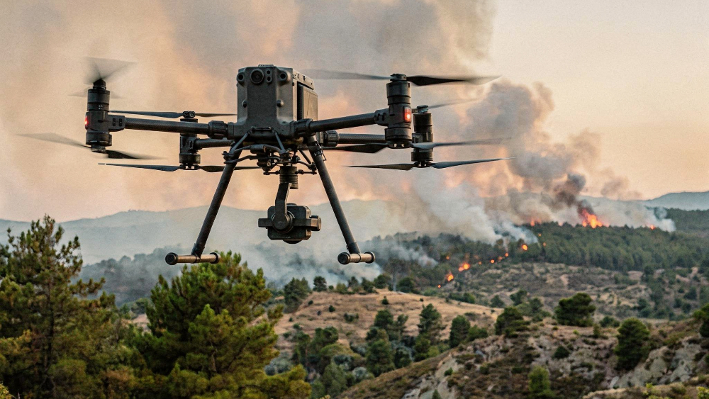
The Calabria Region has launched its 2026 forest-fire prevention and response system. From 15 June to 15 October, the period of highest alert for fire risk, regional regulations are in force across the entire territory, including the ban on lighting fires.
Alongside prevention and control measures, the plan introduces the structured use of aerial monitoring technologies. During the most critical phase of the season, the regional system will be able to use data from 40 piloted drones to support surveillance and territorial monitoring activities.
The use of drones is part of the path launched through the “Zero Tolerance” project, which introduced aerial control tools and a dedicated Control Room for information management. The objective is to identify risk situations more rapidly and make useful data available to the operational structures.
Not just surveillance: towards a stable monitoring network
The Region has presented the Strategic Importance Operation “Forest Fire Monitoring and Early Warning System”, funded with 5 million euros under the PR Calabria ERDF ESF+ 2021-2027 programme.
The project includes around 50 hub stations distributed across the territory, designed to enable take-off, landing and recharging of automatic and autonomous drones. The aircraft will be equipped with thermal sensors, meteorological instruments and communication systems, with automated analyses through artificial intelligence and integration into the regional Digital Twin.
The key point is the continuity of monitoring. The drone is not considered only as a tool to be activated in an emergency, but as part of an observation network capable of acquiring territorial information, georeferencing it and making it available to support operational coordination.
Aerial data in risk monitoring
In forest fires, the time factor directly affects the effectiveness of the response. Identifying the start of a fire in its early stages makes it possible to contain its spread and guide the activation of ground teams and aerial assets with greater precision.
Drones can contribute to the monitoring of hard-to-access areas, the detection of thermal anomalies, the acquisition of georeferenced images and the monitoring of the evolution of the flame front. They can also support post-extinguishing checks and the mapping of areas affected by fire.
In this context, the integration of territorial data, sensors and digital platforms becomes part of the operational process. The value of the drone does not depend only on its ability to observe from above, but on the possibility of producing readable, up-to-date and usable information for those required to intervene.
From observation to information management
The most relevant step concerns the transformation of aerial monitoring into a continuous information system. Before an emergency occurs, the data collected can help identify sensitive areas, vulnerability points and territorial conditions that require closer supervision.
During the event, images, thermographic data and georeferenced coordinates can help reconstruct the scenario in real time: the position of the front, the presence of hot spots, the direction of spread, the accessibility of areas and proximity to infrastructure or residential centres.
After extinguishing operations, thermal monitoring can support the verification of any remaining fire outbreaks, while mapping the affected area makes it possible to document the event and update the information bases used for future prevention.
The issue, therefore, is not the single drone flight. It is the continuity of data: what is detected before the fire guides prevention; what is acquired during the emergency supports coordination; what is measured after the intervention improves risk assessment in subsequent seasons.
From data to operational response
A monitoring system generates value only if the information collected enters a system with defined responsibilities, shared procedures and communication channels that are already active. This is why the regional plan also recalls the role of local administrations, operational structures and citizens.
Municipalities monitor the territory and apply prevention measures. Operational structures manage alerts, response and coordination. Citizens contribute through correct behaviour and timely reporting, also via digital tools such as the “Difendi Ambiente” portal.
Drones, sensors, the Control Room and digital platforms strengthen this organisation, but they do not replace it. Their effectiveness depends on the quality of the information flows: who acquires the data, who validates it, who receives it, who uses it and within what timeframe it can be transformed into action.
It is at this stage that the operational value of technology is measured.
Drones, sensors and digital platforms
The regional plan highlights a relevant step for the professional use of UAS: the drone is effective when it is part of an operational architecture.
The prospect of autonomous hubs, the use of thermal sensors, integration with meteorological tools, artificial intelligence and the Digital Twin indicate an evolution of fire monitoring towards more continuous, structured and decision-oriented systems.
For the UAS sector, the issue does not concern only the flight platform. It concerns the entire data chain: collection, transmission, analysis, security, coordination and use of information in decision-making processes.
The technical discussion developed at Dronitaly
The use of drones in prevention, monitoring and operational support activities in firefighting scenarios was also addressed at Dronitaly 2026, through scientific, institutional and operational contributions that agree in considering the drone not as an isolated tool, but as a system component in the fight against fires.
Its effectiveness depends on the quality of the data collected, its integration with control rooms, the definition of procedures and the ability to support rapid and verifiable decisions.
The Calabria Region plan represents an application consistent with the discussion developed at Dronitaly: prevention, monitoring, coordination and post-event verification are not separate phases, but parts of a single operational process in which UAS can make a stable contribution to environmental risk management.
In the CNR session on 11 March, dedicated to agro-forestry solutions, the programme included use cases relating to fire risk assessment, cadastral mapping of areas, biophysical analysis of forest fuel through UAV LiDAR and multitemporal forest monitoring by drone. The focus is on preventive knowledge of the territory: forest structure, fuel distribution and updating of information useful for planning.
DOWNLOAD THE CNR PRESENTATIONS
On 12 March, during the ISPRA/SNPA conference, the presentation by the Fire Brigade explored the use of RPAS in complex emergencies, with reference to cooperation, coordination and decision support. The scenarios mentioned included wildland-urban interface fires, support for DOS-DTS, night-time monitoring of the flame front and hotspot detection. The central theme is the use of drones to increase situational awareness and reduce operators’ exposure to risk.
DOWNLOAD THE FIRE BRIGADE PRESENTATION
On 13 March, the AERSPO conference explored aerial support in firefighting operations, with a focus on reconnaissance, monitoring and coordination through manned and unmanned aircraft, from the initial survey to the closure of the operational task. The proposed approach places at the centre the integration between airborne assets, live images, telemetry, sensors and control rooms.
DOWNLOAD THE AERSPO PRESENTATION
News sources
ANSA Calabria – Regional firefighting plan launched, up to 40 drones operational
Calabria Region – Institutions and territories united in the fight against forest fires
PR Calabria – Strategic Importance Operation for Fire Early Warning